Search Results
280 results found for ""
- Our Journey to Prince Rupert, BC
We spent our final full day in Stewart, BC on August 14 riding our electric bikes. This was the first time since leaving the states we took them off the storage rack from the rear of the RV. They were filthy with road dust from the ALCAN up and back, so they got a wash down before we took off. We rode through the back streets of Stewart to the boardwalk over the neighboring flat marshland to the road leading to Hyder, Alaska. Our plan was to cross the border one more time, but this time on bicycles. We had no intention of riding out to the bear viewing platform 4.5 miles up the road from the village of Hyder, But, I had my bear spray on me just in case we had an unplanned encounter. The destination today was a small trailer in Hyder, Alaska were we could get some homemade fish and chips prepared by Diana. She is known to have a line waiting and, true to form, we waited an hour for our order because she was once again busy. Overall, not the best I'd ever had but still a fun and novel small town experience. We had fun sharing a picnic table with Keith and Rhonda, a couple we met while waiting for lunch. They recently sold their home in British Columbia and are now traveling full time in their RV. They plan on driving south to Washington, Oregon and eventually wintering in Arizona on the first leg of their journey. We loved sharing stories and encouraging them to continue pursuing their travel dreams. On our return to the campground, we stopped to buy fudge before the Canadian border checkpoint; nothing to declare but bear spray and fudge. We left Alaska on our E-bikes for the last time, really...honest! Riding back to camp to use the internet and phones, we anticipated finding a repair facility for our broken leveling jack leg. We were able to contact a shop in, of all places, Houston, British Columbia about four hours away. I spoke to Mike at SMP RV. He got hold of Lippert Components, the manufacturer of the leveling system, and was able to order a replacement jack for us. He told us that it's expected arrival date would be on Wednesday, August 21 and they would need about two hour to do the installation. Okay, that's taken care of for now. We used the rest of the afternoon to do some needed cleaning, inside and out, and started the familiar process of getting ready to depart the next morning. We spent the evening with Mike and Mary one last time playing 5 up/5 down, a favorite card game. Thursday, August 15 was our departure day from Bear River RV Park. Okay, where do we go to kill some time between Stewart and Houston? Karen talked to Natalie, the owner of Bear River, and asked her about Prince Rupert as a place to visit. Natalie said that's her "go to" place and recommended it. To get there we would drive Highway 37A about 30 miles then head south on the Stewart-Cassiar Highway and connect with the Trans-Canada Highway 16 west (the Yellowhead Highway), to Prince Rupert. The port is approximately 258 miles west of Houston and 429 miles west of Prince George. We drove to Kitwanga River RV Park for one night, about 132 miles south on Highway 37 before the junction with Highway 16. Leaving the next morning, at the junction with 37 and 16, we were greeted by the "the Seven Sisters" mountain peaks to the west. All along the valley are steep granite face cliffs and the swift flowing Skeena River. Seven Sisters Park is named for the spectacular set of peaks visible from Highway 16 between Hazelton and Terrace. We later stopped in Terrace, British Columbia on the Skeena River to do some needed shopping at the local Walmart and eat lunch before driving the rest of the way to Prince Rupert. The drive down the Yellowhead Highway is like a three hour drive through the Yosemite Valley. Spectacular scenery everywhere you look along the entire route. A brief side trip took us to a first nation village with numerous totem poles. Prince Rupert is a port city in the province of British Columbia, Canada. Its location is on Kaien Island near the Alaskan panhandle. It is the land, air, and water transportation hub of British Columbia's North Coast, and about 60 miles south of Ketchikan on the Alaskan panhandle. Prince Rupert has an oceanic climate and is also located in a temperate rain forest. Prince Rupert is known as "The City of Rainbows", as it is Canada's wettest city, with 103 inches of annual precipitation on average, of which 100 inches is rain. In addition, 240 days per year receive at least some measurable precipitation, and there are only 1230 hours of sunshine per year, so it is regarded as the municipality in Canada that receives the lowest amount of sunshine annually. Tourist brochures boast about Prince Rupert's "100 days of sunshine". However, Stewart, British Columbia, receives even less sunshine, at 985 sunshine hours per year. We arrived in "sunny" Prince Rupert and initially parked in the Walmart parking lot at their mall, but decided later to move on. However, while at the mall Karen went in and got a manicure and pedicure she'd been eager to get done while I worked on the blog. We decided to drive down to the restaurant at the Crest Hotel on the waterfront for a dinner out. It was recommended by our host at the Bear River RV Park as one of her favorite places to enjoy a meal and the view. She didn't lead us astray. Karen enjoyed Halibut cheeks and shrimp with ancient grains and vegetables. I went for the Alberta Angus Striploin with Peppercorn sauce, mashed potatoes and vegetables. We really treated ourselves before driving to the Prince Rupert RV Park for the night. Saturday, August 17 we got up and rode our bikes again to do errands. haircuts, and coffee at Tim Hortons (a Canadian institution, Eh?) It was then to Bob's on the Rocks for lunch and more fish (Halibut) and chips. We took walk down the Rushbrook Trail to enjoy the waterfront, ending at the salt marsh and then back again as we worked off lunch. We found some beautiful Foxgloves blooming on the trail I had to get an image of up close. Prince Rupert has a winding system of roads and is a very hilly city, so the E-bikes saved us a challenging ride back to our campground. All in all, it was about 7 or 8 miles of riding. Got back just in time for a nap before dinner. Sunday morning, 11 AM we departed Prince Rupert for Ferry Island Municipal Campground in Terrace, British Columbia for two days. This 150-acre park is situated 3.5 km east of downtown Terrace on Highway 16. It boasts 103 campsites serviced with picnic tables, fire grates, municipal water, and outhouses. There is a caretaker on duty overnight.
- Special Edition, the Bear!
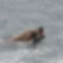
Off in the distance, by a small pond swimming with Chum Salmon, we spotted a solitary brown bear sitting and grooming. Another initial long distance observation on the other side of the viewing platform. We waited... Our bear sighting improved when this awesome creature decided to forge the pond in our general direction. This afforded us a better view as he crossed the water towards the creek that fed this pond. He walked towards us and then disappeared shortly after walking up the creek and out of view. We all thought, okay that's it, happy to have seen at least one bear relatively up close. We patiently waited again and, low and behold, it showed up on the other side of the raised walkway and across the road from us! Now this is close, really close. I had to zoom back my telephoto lens to capture the bear in full frame format! The rangers are extra vigilant when the bears are this close, but it strolled by and down the asphalt road to disappear again through the brush on the opposite side of the road surface and viewing area. Okay, that was an unexpected extra. WOW! But wait...there's more! I positioned myself with a clear view on the viewing platform where the creek passes under the road bridge leading to where the bear entered the brush just hoping it might keep walking to where the fish were in the stream. All this walking must have made our new friend hungry. Our new brown bear friend was now in the main stream with the Salmon and was definitely fishing. It seemed generally relaxed with all the watchful eyes, binoculars and cameras of every shape and size. I had brought my Nikon D750 full-frame digital SLR with a 80-200mm telephoto lens for this occasion. I had no reason to rush or worry about getting a good vantage point. Everyone was happy to have so much time to watch and enjoy the show the bear was putting on for us. How to tell a brown bear from a grizzly bear? While grizzly bears are indeed a subset of brown bears, several key differences set them apart: Habitat and Diet. Grizzlies thrive inland and lack access to marine-based food sources like fish and salmon, distinguishing them from coastal brown bears. After almost an hour I had over 115 still images of this magnificent creature. The venue was incredible for this wonderful wildlife experience. We had talked to others who had spent hundreds of dollars to fly in to see these animals in other parts of Alaska and we did it for a mere $10 per ticket to the viewing platform. As the last light of the day approached, our friendly brown bear retreated back to the woods and our Alaska experience was now complete.
- Three Days in Stewart, British Columbia
Situated at the end of the 90-mile-long Portland Canal, surrounded by majestic forestry and the Cambria Icefields, resides the small town of Stewart. Founded in 1902 by Robert M and John W Stewart, Stewart has been a mineral exploration icon since the early years of the 20th century. By 1910 Stewart and Hyder (then known as Portland City) were joined by a two mile long “road” made from pilings across the tide flats. The area then hosted close to 10,000 people who were still residing in tents, waiting for buildings to be built on the pilings much like the “road” between Stewart and Hyder. Some of these buildings and pilings can still be seen on the tide flats today. Along the 40 miles drive from Meziadin into Stewart, many beautiful glaciers can be seen from Highway 37A. Descending towards Strohn Lake and Bear River Pass is the Bear Glacier. Ice once reached across the road to the rock face, but once it started receding in the 1940’s, it created what is now called Strohn Lake. Stop at this viewing point and take in the breathtaking views of the glacier and the rich forestry surrounding it! We stayed at the Bear River RV Park from Monday, August 12 to Thursday morning, August 15. It is a good sized Campground (70 +/- sites) close to downtown Stewart & Hyder; it has new owners, new gravel sites, new gravel access roads, new electric hookups (30A) & new water hookups. The sites all have shared (full) hookups, essentially making them “buddy sites” - a few spots will function as pull throughs until they fill up. This continues to be a work in progress, with the new owners stepping up to make this the best RV campground in the area. Why Stewart you might ask? Just 5.9 miles from the Stewart Visitors Centre is the Fish Creek Wildlife Observation Site (Bear Viewing Platform) in Hyder, AK. The US Forest Service and The Alaska Department of Fish and Game make sure to offer a safe environment for our wildlife and people. In July and August, tourists make their way up and down this platform to watch the salmon run and bears hunt the salmon. Tuesday morning at 7AM we hitched a ride with our new friends, Mike and Mary from Redding, California, in their truck and crossed the border, yet again into Alaska to get to the viewing platform early. We stuck around for about two hours but unfortunately there were no bear sightings. There ar plenty of Chum Salmon swimming up the river to spawn and die, and plenty of Seagulls getting in on an easy meal, but no bears. We then drove up the dirt road, passed the viewing platform, to the Salmon Glacier. Located on the Canadian side of the border beyond Hyder, AK about 23 miles, you come to the summit of the magnificent Salmon Glacier. The unpaved road leads you up to 4000’ elevation, journeying through rich forestry and old mine sites. On the way back we stopped at the bear viewing platform for another try. No luck again so we drove back over the Canadian border to Stewart to eat some lunch, take a nap and try again at 7PM. Tuesday night proved to be the big payoff. When we first arrived there was no activity, however the rangers were very animated. We knew something was coming soon. We did notice one brown bear at the far end of the platform moving away and really too far to photograph but we took what we got, not know anything else might happen that evening. Boy, did we get a wonderful surprise! Stay tuned for the next episode.
- The Moment of Truth
How easy or difficult would it be to reconnect the RV to the Truck? Well, Thursday August 8 was the day we would do the deed or at least make the attempt. The morning was slow; we slept in and enjoyed the campground. Later in the morning we drove to Carcross to use the internet, make more calls and eat lunch at the local bistro. I was able to find some scrap lumber at a construction site in the village. I told the job supervisor I needed some for cribbing to lift up our trailer and he offered whatever we could use from the free wood pile. I found enough 2x6 lumber to do the trick. We returned to the campsite and I cut the lumber to make blocks I could stack up under the bottle jack I would use to raise the left side of the RV. We added additional tire chocks to all four tires and started the process slowly and methodically. Karen was on the leveling control panel raising the right leveling jack while I lifted the left side with the bottle jack under the frame behind the broken jack. Slowly we raised the trailer high enough to back the truck under the hitch ball in the bed of the truck....kind of! The alignment was off slightly and we tried to correct the centering of the ball but we were still off. I thought we were close enough to try connecting, The scary part is the lack of lowering control using two different systems that are not synchronized together. Karen started retracting the right side at my direction and I released the pressure on the bottle jack as close to simultaneously as possible. BOOM! The trailer goose-neck hitch slipped onto the hitch ball in the truck's bed with a little more energy than I would have preferred. But, good news....we were back together again. Thank you Jesus! We thought about staying the third night, but honestly I just wanted to get back on the road and somewhere we had cell phone service or wi-fi. We had already paid for a third night when the ranger came by to check on our situation. He took pity on us and understood our desire to get back on the road; so much so that he retrieved our payment envelope and returned our money for that one night. It was a really nice gesture that we both appreciated. Everything was packed up; we drove up the hill back to the Klondike Highway, through Carcross and 95 miles back on the ALCAN until it got late enough to pull over at a rest stop for the night. It turns out that Teslin Territorial campground was next to the rest stop; we found a nice long back-in site that was level and settled in at the campground.. Driving on Friday, August 9 we covered 150 more miles in under three hours to Baby Nugget RV Park just outside of Watson Lake, Yukon. Joe at the office set us up with a site that had a slight downhill slope to accommodate our nose high configuration staying connected to the truck. Just east of the RV park is the junction south to the Stewart-Cassiar Highway 37. This was our planned route south through British Columbia. For those traveling to the Yukon and/or Alaska, Highway 16 / 37 offers an alternate route from the Alaska Highway. Much less used than the Alaska Highway, it offers very different scenery (not better or worse, just different), making it perfect as part of a circle route. The Cassiar Highway was completed in 1972, and is asphalt-surfaced with the exception of a short gravel break through the Stikine River valley. The highway passes through hilly and mountainous, mostly wooded wilderness regions where services are found in sparsely populated communities and far from each other. We planned on returning this way, but would the hitch situation make that route problematic? What the heck, we decided we wanted to see new scenery and eventually camp in Stewart, BC before going on to Prince George. So Saturday, August 10 we departed Baby Nuggett RV Park and turned onto Highway 37 heading south. On the Stewart-Cassiar we stopped in Jade City, BC to check it out. Jade City is a settlement in northwestern British Columbia, Canada, near the Yukon, located on Highway 37, west of Good Hope Lake and close to Cassiar, in the Cassiar Highlands. The region around Jade City is rich with serpentinite (a jade precursor), greenstone (jade look-a-likes), and Nephrite jade. Jade City is by road about 19 hours north of Greater Vancouver, and 1 hour south of the Yukon border. As of 2015, it had a population of about 30 people. While we were stopped in Jade City, another Alliance Avenue 32RLS rolled in. We met their owners, Gary and Mickey Vander Veen from Holland, Michigan. They were headed south like us to Lake Kinaskan Provincial Park and eventually Bear River RV Park in Stewart, so we talked about getting together for a future visit and dinner together. We drove 223 miles over four hours and found Lake Kinaskan Provincial Park in Iskut, British Columbia. What a gem! We backed into a lake side spot for only $15 anight! After setting up our campsite we discovered the water pump no longer worked, but fortunately I had purchased a new pump while we were in Florida earlier in the year anticipating the need to replace it eventually. That had day arrived. Day two at the lake was spent replacing the water pump and repairing some of the rubber trim seals around the slide outs. We could have stayed here for a week without blinking. Just an INCREDIBLE location!!!!
- Back to Alaska?
August 6th was our 29th wedding anniversary which we spent traveling, shopping, setting up camp at Conrad and exploring the small town of Carcross. We celebrated with a delicious dinner at The Bistro in Carcross. When the young ladies at the restaurant found out it was a special occasion, they treated us to a delicious dessert on the house; such a kind gesture and a blessing for us! The Conrad Campground is off the Klondike Highway 10 miles south of Carcross and is very close to the border shared between the Yukon Territory and Bristish Columbia. As you drive Highway 2 south into British Columbia you're traversing a famous and historic route from Skagway, Alaska over the White Pass to Whitehorse, Yukon. White Pass, also known as the Dead Horse Trail (elevation 2,864 ft) and is the mountain pass through the Boundary Ranges of the Coast Mountains on the border of the U.S. state of Alaska and the province of British Columbia, Canada. It leads from Skagway, Alaska to the chain of ribbon lakes at the headwaters of the Yukon River (Crater Lake, Lake Lindeman, and Bennett Lake). The White Pass trail was one of the two main passes used by prospectors during the Klondike Gold Rush. The White Pass was an easier route to Lake Bennett than the Chilkoot Trail a few miles to the west, but it harbored a criminal element that preyed on the cheechakos (newcomers to the Klondike). These con artists were believed to be members of the infamous Soapy Smith gang from Skagway, Alaska. In 1898, Smith was killed at the famed Shootout on Juneau Wharf and his gang were run out of Skagway and the White Pass. So many horses died during the gold rush, the trail became known as the "Dead Horse Trail". The trail ended at Lake Bennett, where the prospectors built or purchased rafts or boats to float down the Yukon River to the Klondike gold fields near Dawson City. Our ultimate destination for our Wednesday, August 7 day trip into Alaska was the historic town of Skagway. We had booked tickets on the famous White Pass and Yukon Route Railroad for the 2:30 PM trip up to the White Pass summit and back. The White Pass and Yukon Route (W.P. & Y.R.) is a narrow-gauge railroad original built between 1898 and 1900 through White Pass. Today, tourists from all over the world book trips on the W.P. & Y.R. to see the historic route from the Klondike Gold Rush era. Before our train ride we walked the Broadway of Skagway. Four cruise ships were in port so the town was awash with tourists. After walking around a bit we stop in a bakery/coffee shop. We got hold of Alliance RV back in Elkhart, Indiana to try and determine the best course of action for the broken leveling jack. Customer service was extremely helpful and we now have a plan to execute when we get back to the rig. But for now, it's time to enjoy a beautiful sun soaked Alaskan port of call. We took the WHITE PASS SUMMIT EXCURSION to experience this unique railroad that symbolizes accomplishments in adventure and pioneering – of triumph over challenge. We relaxed in a vintage passenger coach and retraced the original route to the White Pass Summit, passing Bridal Veil Falls, Inspiration Point and Dead Horse Gulch. We enjoyed a breathtaking panorama of mountains, glaciers, gorges, waterfalls, tunnels, trestles and historic sites. From the train we could see the original Klondike Trail of ‘98 worn into the rocks, a permanent tribute to the thousands of souls who passed this way in search of fortune. The train ride was spectacular and we finished the experience with a wonderful seafood dinner on the Skagway waterfront before returning to the truck and driving back to Canada back up the Klondike Highway. The day in Skagway gave us a chance to decompress and enjoy ourselves. Tomorrow we'll get the trailer reconnected to the truck.
- Broken Leg...Oh No!
Without cell service or internet connectivity, keeping up with posting the journey is difficult. I've resorted to writing our daily trip down in an Apple Pages document, then cutting and pasting to the blog when we get service. The last two weeks have been tough for posting due to the remoteness of our camping sites. From our rest area stop for the night outside Tok, Alaska on Saturday, August 3rd we drove most of Sunday on the ALCAN to the international border back into the Yukon, Canada. Having experienced the ALCAN already on the trip north we knew what to expect. We dropped our traveling speed during this entire section and took the frost heaves and damaged road surface considerably slower than when we drove up. Even still, every now and then, a surprise was waiting for even the most vigilant. At one safety stop to check the interior of the rig, we discovered yet another open cabinet and a broken book shelf behind the TV. After almost three hours and 158 miles of ALCAN treatment, we were ready to rest up. We stopped for the night in Beaver Creek, Yukon at the Discovery Yukon Lodgings where we dry camped. Monday morning, August 5th we continued trekking another 207 miles on to a rest stop near Stony Creek Camp, Yukon just outside Whitehorse. It was another long driving day, almost four hours worth, but Karen is now sharing the driving duties. And do tell, she even confessed enjoying the experience. When we arrived at this rest stop we encountered a fellow traveler in distress. It turned out that their Class C towing a boat had a flat on the dually rear tire on the passenger side. Not the outside tire, no...the INSIDE tire and the owner was a without a long enough ratchet extension to get the tire off. This was an ordained opportunity to lend a hand because I had everything he needed. He got the tire off, changed it, and was back on the road headed for the local lake extremely appreciative. I told him we were meant to minister to his circumstances and I blessed his journey as we parted. It was a short 45 minute drive into Whitehorse to the Walmart, Canadian Tire and Save-On grocery store. We got the needed groceries, DEF and truck fuel before leaving town for Conrad campground outside of Carcross, Yukon which was another hour away and our home for the next three days...we thought! The south end of the Tagish Road is in Carcross, Yukon. Carcross is also on the White Pass and Yukon Route railway between Whitehorse and Skagway. Carcross is mainly known for its world class mountain biking on the near-by Montana Mountain, and for the nearby Carcross Desert, often referred to as the "world's smallest desert." Carcross was originally called “Caribou Crossing” because of the large number of woodland caribou that migrated through the region. About ten miles south of Carcross, is a territorial campground on the shores of Tagish Lake near the now-abandoned town of Conrad City that supported the Venus silver mine in the early 1900s. We found a perfect site, long enough, level enough and near enough to the pit toilets and "bear proof" garbage containers to suit our needs. However, in the process of disconnecting from the truck, we encountered a problem lowering the left-front jack. I could tell the motor was laboring to lift the trailer and before it was up high enough to detach from the truck it stopped raising the trailer. I had to lower the front of the trailer to add more leveling blocks and tried again. We got the trailer up high enough to disconnect and pulled the truck away to start the leveling process. As we were lowering the front jacks together, the left jack suddenly collapsed 3 to 4 inches to the adjustable pin stop. Scared the "you know what" out of me. After some very careful maneuvering I was about to lower both jacks down with enough shoring material to make the rig stable. When I went to try and raise the front jack and test the two together one more time, only the right jack would engage and lift the trailer. Bottom line - we had a broken left jack leveling leg assembly. And well, that stinks....right? Nothing like being in a remote location with no cell service, internet, electricity, water or sewer services with a broken trailer leveling jack disconnected from your tow vehicle. Does this sound familiar? Time for SEMPER GUMBY and to work the problem. Let's look at what was good. First, no one got hurt! Second, we have plenty of solar power and sun, a back-up generator with fuel, enough water on board and empty black and gray tanks. Third, I have a 7-ton hydraulic bottle jack on board to lift the left side of the trailer. And finally, the trailer is almost level (a few degrees low in the front) with chocked tires and a solid foundation. What I will need to reconnect eventually is more wood blocks for cribbing the left side of the trailer frame. Enough for now. We drove into Carcross to do some sightseeing, including the "world's smallest desert" and the Emerald Lake, known as “Rainbow Lake” by the First Nations. Emerald Lake offers a breathtaking view on its truly emerald-green water surrounded by Surprise Mountain and Mt Gilliam and is located along the Klondike Highway, 7 miles north of Carcross. We enjoyed the local sights and planned a day trip to Skagway, Alaska to ride the White Pass and Yukon Railroad the next day. The jack problem will wait.
- Our Final Week in Alaska...kinda!
Finally the time to move on from Valdez was Tuesday, July 30, 2024 when we travelled to Kenny Lake Mercantile Campground to spend one night. It was just off the road to Chitina, McCarthy and eventually the Kennicott Mines National Historic Landmark. Kennicott Mines is an abandoned mining camp in the Copper River Census Area in the U.S. state of Alaska that was the center of activity for several copper mines. It is located beside the Kennicott Glacier, northeast of Valdez, inside Wrangell-St. Elias National Park and Preserve. The camp and mines are now a National Historic Landmark District administered by the National Park Service. We had hoped to visit but alas the weather wasn't idea for the long trek 60 miles down a rough road to McCarthy. We are making a mental list of things to see on our next vist to Alaska and this was added. Wednesday morning we drove to the Tazlina Trading Post to visit with our friend Laurie Johnson. She met us with our mail forwarded from Texas and gave us a local tour of the Glennallen area where she and Jay now live. We missed Jay, because he and his brother took a road trip to Prudhoe Bay on their motorcycle for the week. After our tour, we took Laurie to lunch at the Copper River Princess Wilderness Lodge. which features spectacular mountain views and breathtaking scenery of Wrangell–St. Elias National Park. The Copper River Princess Wilderness Lodge is situated on 200 acres near the junction of the Klutina and Copper Rivers. This premier Princess Alaska Lodge features 85 rooms and a two-level dining area with excellent mountain and valley views. The focal point of the Copper River Princess Wilderness Lodge is the Wrangell Room with a staircase to the mezzanine level where you can relax and enjoy the majestic scenery provided by a two-story wall of windows. From Glennallen we drove up the Richardson Highway north to stay at the Rest Stop at Mile Post 188 for the night, which is past the Denali Highway turnoff. We had originally planned on stopping to camp at Paxson Lake but couldn't find a suitable site to fit our rig so we just pulled off the highway for the night before finding a camp site for the next two days. We met a departing RV as we arrived and took over their beautiful lake view site. That next day we drove west on the Denali Highway until the pavement ended at Tangle Lake. This BLM-maintained campground sits amid the Tangle Lakes, a series of long, narrow lakes. This is a designated put-in for the 30-mile-long Delta National Wild and Scenic River float trip. There are moose and caribou in the area; many hunters use this as a base camp during the fall hunting season.The Denali Highway is 135 miles long and connects Paxson on the Richardson Highway with Cantwell Junction on the Parks Highway. Only 30 miles of the road surface is paved. We used this as a base to explore more of the Denali Highway route, without the trailer, and more of the Richardson Highway north to Delta Junction through the Alaska Range. This area is where the Trans-Alaska Pipeline System (TAPS) spans Alaska, including the trans-Alaska crude-oil pipeline, 12 pump stations, several hundred miles of feeder pipelines, and the Valdez Marine Terminal. TAPS is one of the world's largest pipeline systems. The core pipeline itself, which is commonly called the Alaska pipeline, trans-Alaska pipeline, or Alyeska pipeline, (or The Pipeline as referred to by Alaskan residents), is an 800-mile (1,287 km) long, 48-inch (1.22 m) diameter pipeline that conveys oil from Prudhoe Bay, on Alaska's North Slope, south to Valdez, on the shores of Prince William Sound in southcentral Alaska. The crude oil pipeline is privately owned by the Alyeska Pipeline Service Company. After two days of on again/off again wet and dreary weather, we concluded that it was indeed time to start thinking about the trip back to the lower forty-eight. We had spent over a month experiencing Alaska and needed to consider the long journey ahead and the travel time to get to Washington state by Labor Day. We didn't want to rush back so we decided on Saturday morning, August 3rd we would depart Tangle Lakes to drive south on the Richardson Higway to the Tok Junction to head north back to the ALCAN. We drove most of that distance and found another pull-out for that night before we reached Tok, Alaska. Another beautiful Alaska summer gone by, marked by fireweed flowers going to seed as salmon runs shift to Coho and start to dwindle. As the saying goes: “when fireweed turns to cotton, summer will soon be forgotten." Our time in Alaska has been memorable and extremely rewarding. We leave with a few disapointments. Not being able to experience Denali Ntional Park was the big one, but overall we had some wonderful adventures with friends. And like most trips to new and faraway places, the idea of returning at some future date is definitely going to be on the table. A future trip to Alaska, done in a different manner, at a future time is already in conversation. But for now, the long road back south begins in earnest. Good bye Alaska...for now.
- Four more days exploring Valdez
On Friday, we returned to the Valdez Fisheries Development Association Inc., (VFDA) which operates the Solomon Gulch Salmon Hatchery here in Valdez, Alaska. Constructed in 1982, the Solomon Gulch Hatchery is permitted to incubate 270 million Pink Salmon eggs and 2 million Coho salmon eggs annually. Each year starting in mid June, the Solomon Gulch hatchery awaits the return of it’s Pink salmon. An average return is about 10 million adults. After harvesting a small percentage of the return for cost recovery, the remainder is harvested primarily by the Commercial purse seine fishermen and the sport fishermen. In addition, VFDA collects approximately 400,000 adults for brood stock. August is for Coho’s. The annual return of adult Coho to Valdez is between 150,000 and 250,000 salmon. This allows the community of Valdez to sponsor the Valdez Silver Salmon Derby with great success. The best time for sport fishing Coho’s is late August through Labor Day. It is a very busy place and a great venue to see the migration of Salmon, as well as Steller sea lions, seagulls, bald eagles and if you're lucky...black bear. I took a chance and flew the drone to capture video and still photos of the scene. My biggest concern was the number of seagulls competing for the airspace. I had one minor collision with a seagull but thankfully the drone stayed in the air. Friday would be our last day together with the Earleys; Sean and Kathy wanted to get back on the road to the lower forty-eight on Saturday morning. So, we sent them on their way in the rain with our thankfulness for making the journey together a great experience. They were the easiest traveling companions we could hope for on a trip of this length and complexity. The Earley’s are about as easily going as any couple we’ve ever met, a perfect fit and just plain fun! Before leaving we prayed a blessing over their journey for traveling mercies back east to Pennsylvania, by way of Washington State.. We will truly miss their company. So it's back to Karen and I only. With the weather still cloudy and unpredictable we stayed close to town. We journeyed out to the old Valdez town site and then up to the Valdez Glacier past the airport. We went into town by the waterfront to try lunch at the Fat Mermaid and later took in the local ‘Magpie Follies’ show. This is a funky revue of local history with song and dance; low budget, low expectation realized. Sunday we got up early to attend church on board the Lu-Lu Belle, a tradition that Captain Fred has done for years. Normally, he takes to boat out for about an hour service, but unfortunately his vessel was down for repair of one of the two starter motors, so we fellowshiped at the dockside. Breakfast was at the Potato Roadhouse Cafe then to Coast Guard Station Valdez for a brief visit. We finished our tour of Valdez on Monday, July 29th with a bit more history taking in the two Valdez Museums. Two Infamous event in Valdez were the spotlight and both occurred in the month of March. The 1964 Alaskan earthquake, also known as the Great Alaskan earthquake and Good Friday earthquake, occurred at 5:36 PM AKST on Good Friday, March 27, 1964. Across south-central Alaska ground fissures, collapsing structures, and tsunamis resulting from the earthquake caused about 131 deaths. Lasting four minutes and thirty-eight seconds, the magnitude 9.2–9.3 megathrust earthquake remains the most powerful earthquake ever recorded in North America and the second most powerful earthquake ever recorded in the world since modern seismography began in 1900. Six hundred miles of fault ruptured at once and moved up to 60 ft (18 m), releasing about 500 years of stress buildup. Soil liquefaction, fissures, landslides, and other ground failures caused major structural damage in several communities and much damage to property. In Valdez alone, stresses generated by the seismic shocks and the slide developed an extensive system of fissures throughout the unconsolidated deposits at the head of the fjord. These fissures plus the shocks caused structural damage to many of the buildings in Valdez and destroyed the sewer and water systems. This event caused an underwater landslide that washed away the waterfront area of Valdez and resulted in the loss of 32 lives. Then on March 24, 1989, the Exxon Valdez oil tanker ran aground and produced a massive oil spill that impacted the Prince William Sound. The Exxon Valdez spill is the second largest in U.S. waters, after the Gulf of Mexico's 2010 Deepwater Horizon oil spill, in terms of volume of oil released. Prince William Sound's remote location, accessible only by helicopter, plane, or boat, made government and industry response efforts difficult and made existing response plans especially hard to implement. The region is a habitat for salmon, sea otters, seals, and seabirds. The oil, extracted from the Prudhoe Bay Oil Field, eventually affected 1,300 miles (2,100 km) of coastline, of which 200 miles (320 km) were heavily or moderately oiled. The region is still recovering to this day. We departed Valdez on Tuesday, July 30th .hoping for better weather for our last week in Alaska..
- The Lu-Lu Belle Cruise
The Lu-Lu Belle was built by her owner and Captain, Fred Rodolf. The plans were approved by the Coast Guard in Washington D. C.. In November of 1976 Captain Fred purchased a 65 foot Kelly Hull from Westport, Washington and went to work. For the next 10 months Captain Fred became Carpenter Fred and in September of 1977 the Lu-Lu Belle became certified by the United States Coast Guard. He some years later added a ten foot stern platform making the overall length 75 feet, which is her present configuration. The Lu-Lu Belle is powered by two 650 horsepower, 6 cylinder 993 cubic inch Luggers. They are turbo charged and can produce a cruising speed of 20 knots. The Lu-Lu Belle has been the home for Captain Fred and his wife Megan for the past 46 years. In 1985, Admiral Megan and Captain Fred bought some property and built an office on Kobuk Drive in Valdez. When 1986 came around Captain Fred was ready to operate on his own offering Columbia Glacier and Wildlife Cruises with his family. He has run all of his own cruises since 1979 and has logged 5,241 Columbia Glacier cruises. His enthusiasm for sharing Prince William Sound with his guests is readily apparent as he shares a wealth of information and stories in a lively narration. He often goes off the beaten path looking for everything that swims and flies. We boarded at 10:30 AM and departed the dock soon after and headed for the Prince William Sound. This body of water is off the Gulf of Alaska on the south coast of the U.S. state of Alaska. It is located on the east side of the Kenai Peninsula. Its largest port is Valdez, at the southern terminus of the Trans-Alaska Pipeline System. As we proceeded to the Sound we encountered numerous fishing boats working the near shore. These fishing boats, according to Captain Fred are "Purse Seine" fishing for Pink Salmon with a net. The net is kept floating by synthetic corks arranged on the surface and a skiff drags one end of the net around a school of salmon to enclose them in the bag; the net is then hoisted on board with a driving pulley and a winch. We watched the process as Captain Fred came up very close to the fishing boat. I thought he was getting some fresh fish from the Sea Prince! Continuing out to the Prince William Sound we surveyed the rocky shoreline for Steller sea lions and Puffins. Captain Fred found both as we cruised to the Columbia Glacier. Steller sea lions are the world’s largest species of sea lions. The adult male Steller sea lion can weigh up to 2,400 pounds and will grow to be 3 times the size of an adult male grizzly bear. During the summer months, they congregate at rookeries or breeding grounds where they breed, give birth, and nurse their pups. In Alaska, it was found that females return to the rookery where they were born in order to breed. Two species of puffins can be seen in Prince William Sound near Valdez: the horned puffin and the tufted puffin. Horned puffins are named for the black skin "horn" above their eyes. Tufted puffins are named for the tufts of feathers that extend from the back of their heads. Captain Fred is a master at boat handling and maneuvered the Lu-Lu Belle into some small inlets where the birds like to hide out. With the aid of his First Mate on the bow, he could drive with in a few feet of the rocky walls for the best views. Some of the guest who had positioned themselves on the bow had to avoid small waterfalls off the cliffs from above. We navigated out the Valdez Passage and spotted a humpback whale sounding before making the turn into Columbia Bay. At first, the waters at the entrance appear very similar to the Prince William Sound but as we proceeded further into the bay we spotted small, turquoise blue icebergs ahead. The ice volume in the water increased as we continue into the bay. Some of the drifting ice is white, some clear and even blackish gray. These are all produces from the Columbia Glacier that have broken off or "calved" from the face and now drift south to the open sea.. The air temperature is decreasing as we enter this natural "ice box" and it is difficult to spend time outside with the windchill created by the moving vessel. The Columbia Glacier descends from an icefield 10,000 feet above sea level, down the flanks of the Chugach Mountains, and into a narrow inlet that leads into Prince William Sound in southeastern Alaska. Captain Fred pilots the Lu-Lu Belle past a "raft" of Sea Otters on a ice raft through the increasing ice field and motored us up to a mere quarter mile from the massive face of the Glacier. This is an amazing natural wonder and we are fortunate to see this five mile across structure. The best part of all is Fred is in no hurry to get back to Valdez so we just drift and listen, take photographs and videos. Words cannot adequately express the majesty, magnificance and wonder of what we've seen and experienced in Alaska. The Lu-Lu Belle was a high point for us and we're so happy that we got to spend this long, nine hour day with Fred and his crew! This one excursion, in my opinion, is a must see and do if you ever come to the 49th state. Everything rolled up into one package.
- Goodbye to the Guidi's
Monday morning, July 22 had to come eventually and we all knew parting would be emotional. I knew when we first talked about Dana and Jeff coming up this summer, they would be a great fit with Sean and Kathy and we'd all have some excellent adventures during the two weeks they spent with us in Alaska. Without a doubt some wonderful memories were made during our time together. To facilitate the necessary return to Anchorage, we strategically camped close enough to get their RV back to the Great Alaskan Holidays in less than an hour. Their flight out of the airport was scheduled for 2 PM. Because traffic on the Seward Highway can be slow due to the limited number of lanes and the possibility of an accident, we all departed from Williwaw Campground around 9 AM and drove back up north. Sean, Kathy, Karen and I proceeded to the local Costco, Walmart and O'Reilly's for needed supplies for the coming weeks. From there we drove north to the Glenn Highway east through Palmer, Chickatoon and along the Matanuska River to Victory Bible Camp. Victory Bible Camp (VBC) was suggested to us by Jay and Laurie Johnson, a SOWER couple we met and became friends with in Florida while working at Camp Lake Swan. They live in Glennallen, Alaska and knew VBC had RV hook-ups and might accommodate us for a couple of nights. We called the camp from Anchorage and they graciously opened their facilities to us for a donation only. In 1941, several Alaskan missionaries met together and discussed the benefit of gathering yearly for a time of spiritual refreshment. One of these missionaries, John Gillespie along with his wife Nadine, had developed a desire for beginning a Christian camp with the the purpose of “seeing people come to Christ and others dedicating their lives to the Lordship of Jesus Christ.” An extensive prayer list pinpointed the requirements for a camp and conference site, including such priorities as a lake surrounded by high ground, good water supply, and accessibility to a main road. Each item was found in a site on Index Lake. Alaska was then a territory, so it was necessary for bills to be introduced in the U.S. Congress to make the purchase of the first 80 acres possible. Finally founded in 1947, Victory Bible Camp began its legacy of being a place where young and old could come and experience God in a beautiful, mountainous setting. Located 95 miles northeast of Anchorage, Victory has grown from the original 80 acres to over 400 in this beautiful valley between the Talkeetna and Chugach mountain ranges. The campus has also grown over the years to include facilities that can accommodate as many as 300 people. With the dedication of Miracle Lodge in 2003, Victory now has a central dining and office facility located at the heart of its campus. Not only did we have full hook-ups but they included a beautiful lake front view out our back window. We decided to stay two nights, recharge the battery banks and get some laundry done. Around the lake and camp are multiple types of wildflowers along with the wildlife. While flying my drone I observed a beaver and loon in the lake As we're sitting outside enjoying the waterfront view, we get a text from Jeff. Their airline flight was canceled apparently due to the CrowdStrike Internet outage. As CrowdStrike immediately explained to customers and the world, the problem was not a cyberattack but an error in the software update. Because the bug was in CrowdStrike's Falcon platform update for Microsoft Windows, computers using other operating systems (e.g. Mac and Linux) were not impacted. But Jeff and Dana were booked on Delta Airline which was affected. In fact, Delta Air Lines is under investigation by the U.S. Department of Transportation's Office of Aviation Consumer Protection as the airline scraps hundreds of flights for a fifth straight day after a faulty software update from cybersecurity company CrowdStrike took down Microsoft systems around the world. Jeff and Dana were able to get a hotel room for the night in Anchorage and eventually flew out the next day on Alaskan Airlines. An unfortunate ending to their wonderful trip, but they made the best of the circumstances. I wish they could have stayed another week and avoided the hassle.
- Valdez, the Switzerland of Alaska
We left Victory Bible Camp on Wednesday, July 24 and drove the rest of the Glenn Highway to the junction with the Richardson Highway in Glennallen, Alaska. Glennallen gets it name from Major Edwin Glenn and Lt. Henry Allen, both leaders in the early explorations of the Copper River region. The name was originally written as two names, but later made into one word by the post office. This .was our fuel and propane fill stop before continuing south to our eventual destination of Valdez, AK (209 miles) almost 4 hours of driving away. The Richardson Highway is probably the most picturesque part of our journey yet. Leaving Glennallen you are presented with Wrangell - St Elias National Park & Preserve to the east. According to the Crown of the Continent film produced for the National Park Service; "Soar above mountains and glacier-carved valleys still emerging from the Ice Age. With calving glaciers in hidden fjords, wildlife wandering a vast land and countless unnamed peaks, Wrangell-St. Elias fulfills the romantic, mythic image of Alaska. This single national park contains the greatest concentration of glaciers outside the polar ice caps, nine of the 16 highest peaks in the United States, the largest piedmont glacier and the highest coastal range in the world." We continued south over the Thompson Pass, a 2,600 foot-high gap in the Chugach Mountains northeast of Valdez, Alaska. It is the snowiest weather station in Alaska, recording 500 inches of snow per year on average. One of the most noteworthy sites and popular stops on Thompson Pass is Worthington Glacier. Worthington Glacier is one of Alaska’s most accessible glaciers, easily seen right from the road when traveling down the Richardson Highway. At four miles long and encompassing a whopping 5,744 acres, Worthington Glacier is a valley glacier. We considered camping at Blueberry Lake Campground located in Thompson Pass, 24 miles north of Valdez. It is an Alpine Lake with Arctic grayling & rainbow trout. 25 Dry Campsites were indicated but after driving through it was apparent to us the sites were too small to accommodate us comfortably, so we pressed on. Next we passed through Keystone Canyon. It is a place of spectacular waterfalls, magnificent geology and fascinating history. Keystone Canyon is located at miles 14 through 17 on the Richardson Highway. This is home to two incredible waterfalls; Bridal Veil Falls and Horsetail Falls. Bridal Veil Falls, on the left side of the hightway, cascade down hundreds of feet through the canyon and into the Lowe River. In the wintertime, the falls freeze into a towering column of ice. Horsetail Falls is on the right of the Richardson Highway next to a convenient turnout. The entire route is decorated with wildflowers including bright magenta colored Fireweed. Just before the Dayville Road turn to the Solomon Gulch Hatchery we spotted an abandoned truck weigh station with a huge turnout. it looked perfect for two RV's and provided us enough room to park with our trailer doors facing each other. This is where we would park for the next four days unless someone chased us off. In Alaska, it is commonplace to see RV's of all shapes and sizes parked on paved and gravel turnouts. The freedom to not be crammed into RV parks with limited space is considerably more desirable. The benefits of plenty of battery power, fresh water and empty black/gray water tanks affords us the luxury to pick a more remote but comfortable venue close enough to town but for free. The next four days in Valdez were going to be a truly an Alaskan treat. Starting on Thursday, July 25 we booked a trip with Captain Fred Rodolf on board the Lu-Lu Belle. He takes you to the mighty Columbia Glacier, the second-largest tidewater glacier in North America and the largest in Prince William Sound. We hoped to experience some of the most spectacular calving events in the world from the decks on the Lu-Lu Belle, seeing for ourselves the ice falling into the sea causing thunderous explosions resulting in massive plumes of spray and wave activity. He is known to stay at the glacier for at least an hour to make sure everyone has a chance to photograph and/or record some of those amazing events. So stay tuned!
- Williwaw, Whittier and Girdwood
The Williwaw Campground is at mile 4 of Portage Glacier Road on the way to Whittier, AK. It is an idyllic area, sitting beside Williwaw Creek near the town of Girdwood, Alaska and where we would spend the weekend before returning to Anchorage. We all arrived on Saturday, July 20th and found three campsites together and close enough to hear the waterfalls from the mountains above the creek. The campground sits in the Portage Valley of the eastern Kenai Peninsula in the Chugach National Forest. The Forest, spanning 5,361,803 acres is comprised of arid tundra wilderness, jagged mountains, deep fjords and glacier-fed rivers that surround the Prince William Sound. The area is a great place to view numerous glaciated valleys and the Portage Glacier. Over the past 80 years, the glacier calved large icebergs into Portage Lake, located just east of the campground. We traveled here to visit two very different places. If you drive the Portage Glacier Road heading east from Williwaw Campground for about 3 1/2 miles you pass through Anton Anderson Memorial Tunnel, the longest combined vehicle-railroad tunnel in North America. On the other side of the tunnel you arrive at the pristine wilderness at the head of Passage Canal and find the city of Whittier nestled between breathtaking mountains, emerald forests, and a sparkling blue sea. Whittier is a gateway to the mesmerizing wilderness of the Prince William Sound and each summer, thousands of visitors arrive at this magnificent city by ship, train, or car. We visited Whittier for just the afternoon, driving in after setting up our campsite back at the Williwaw Campground. The town of Whittier has a colorful history but really got established just before the second world war. Shortly before the Japanese attack on Pearl Harbor in December 1941, Simon Bolivar Buckner Jr., the American general in charge of Alaska’s nascent Defense Command, began looking for a location for a secret military installation to ferry troops and cargo to the growing hubs of Anchorage and Fairbanks in the Alaskan interior, where strategically important airfields and army facilities were being built. Buckner’s proposed base had three provisos: access to an ice-free deep-water port, natural protection from airstrikes, and radar-unfriendly topography. The rugged nodule of land at the head of Passage Canal, with its seemingly omnipresent clouds and impassable mountains, fit the bill perfectly. Indeed, the mountains around what would become Whittier were so impassable, the military first had to blast a hole through them to link the proposed port by rail to Anchorage, 60 miles away. Although there was already a rail link from Anchorage to Seward, 58 miles to Whittier’s south, the existing line was in poor condition and subject to avalanches, sabotage, and winter closures. The genius behind the tunneling operation was Anton Anderson, a New Zealander who came to the U.S. in 1914 as a surveyor before graduating from Seattle University with a degree in civil engineering. By 1916, Anderson had installed himself in the U.S. territory of Alaska, where he played a key role in the development of the burgeoning Alaska Railroad. The Whittier project was a trickier proposition. Two successive tunnel segments were needed to connect the planned military facility to the main Seward–Anchorage railroad along a 14-mile spur. Tunnel digging began in November 1941 and, despite two-story snow drifts and subzero temperatures, was completed a year later, six months ahead of schedule. The project had taken on a new urgency in June 1942 when the Imperial Japanese Navy took aim at the Aleutian Islands—bombing Dutch Harbor on Unalaska and invading the outlying islands of Attu and Kiska—and turned Alaska into an active theater of war. The volume of traffic on the Alaska Railroad quickly tripled as defenses were shored up to prevent a full-scale Japanese attack of mainland Alaska, with fortifications taking shape at Fort McGilvray near Seward, Fort Richardson close to Anchorage, and Ladd Field outside Fairbanks. Some fun facts about the Anton Anderson Memorial Tunnel include: (13,300 feet or 2.5 miles). Longest combined rail and highway use tunnel in North America. First U.S. tunnel with jet turbine and portal fan ventilation. One way traffic. Whittier Tunnel traffic alternates direction every half hour. You can enter into Whittier at the bottom of the hour (at the 1/2 hour mark). Traffic leaves Whittier on the top of the hour. It takes approximately 6 minutes at 25 MPH to travel through the tunnel at a cost of $13 round-trip for Class 'A' vehicle. With our RV (Class B2) the trip is more expensive and would be $32 not including the cost of an RV site. Whittier isn't very large, so visiting the town is an easy day trip. We only spent a couple of hours there to eat lunch, ice cream and purchase gasoline for our generators back at camp. Princess Cruises had a ship in port and it appeared that many of the passengers from the ship boarded the Alaska Railroad for the day. We returned through the tunnel past some impressive views of the Portage Glacier Lake on our way back to camp. On Sunday, we realized that this would be the last day to spend with Jeff and Dana Guidi before the end of their Alaska adventure. They hadn't seen much of the Alaskan wildlife, so we made plans to visit the nearby Alaska Wildlife Conservation Center in the morning. The Alaska Wildlife Conservation Center (AWCC) is a sanctuary dedicated to preserving Alaska’s wildlife through conservation, education, research and quality animal care. Most of the animals that have come to AWCC have either been orphaned or injured. With consent from the Alaska Department of Fish and Game, animals taken in by AWCC are cared for by animal care staff and are given a permanent home at AWCC. Admission was $25 per person and overall a bit of a disappointment for all of us. The roads into the Center are poorly maintained for the amount of vehicle traffic they receive. Unfortunately, many of the animals were difficult to view in their enclosures. Either they were hiding, sleeping or just difficult to see past the natural plants inside their habitats. A raised viewing platform was available over the bear enclosure which was a welcomed feature. Other raised walkways would add benefit and a recommendation I would suggest. Even though I didn't really enjoy the experience, I felt some satisfaction about the money going to a worthy cause helping either orphaned or injured wildlife. But I couldn't escape the impression that we had just visited a low-budget zoo. The irony for me frankly was I had seen more wildlife in the "wild" over the last six weeks than we did at the AWCC facility. Following our visit to the Alaska Wildlife Conservation Center, Karen and I along with Jeff and Dana drove up to the town of Girdwood, Alaska for lunch. Karen needed to connect to the internet to do some work for an hour, so we left her at a small, local coffee house and went exploring further up the road. We found the Alyeska Resort, a premier year-round destination, featuring over 300-rooms, many fine dining experiences, a saltwater pool, ski mountain and bike park along with the new Nordic Spa. The resort facilities also include an aerial tram that take a seven-minute scenic ride from Alyeska Resort to the top of Mt. Alyeska. At an elevation of 2300 feet, one can witness frosty views of the Turnagain Arm, up to seven “hanging” glaciers, and endless peaks deep into the Chugach Mountain range. Had I known more about the resort we could have had lunch at the deli at the top of the tram! Bummer Karen wasn't with us too. She could have worked there instead. We only looked around but I made a point to remember this resort for a future trip back to Alaska. This is a bucket list item for sure!